Difference between revisions of "Eyesis4Pi 393"
From ElphelWiki
(→Features) |
|||
| Line 32: | Line 32: | ||
* Final panoramic image equirectangular projection dimensions - 14000x7000 | * Final panoramic image equirectangular projection dimensions - 14000x7000 | ||
* 0.05 Pix stitching precision | * 0.05 Pix stitching precision | ||
| + | * Very small parallax - distance between entrance pupils: 46.5 mm | ||
| + | * High resolution lenses: 26x M12 lens mount | ||
* Calibrated fixed lens to compensate for the lenses distortions | * Calibrated fixed lens to compensate for the lenses distortions | ||
**10" (0.1 pix) in the center 80% x 80% area | **10" (0.1 pix) in the center 80% x 80% area | ||
**30" (0.3 pix) maximal error over the full FoV | **30" (0.3 pix) maximal error over the full FoV | ||
**<0.03um/° thermal expansion | **<0.03um/° thermal expansion | ||
| − | * 5 FPS - maximum frame rate | + | * Precise image capture synchronization |
| + | * 5 FPS - maximum frame rate | ||
| + | * RAW or compressed image formats | ||
| + | * Images are geo-tagged - 5Hz GPS receiver ([https://www.pololu.com/product/2138 Locosys LS20031]) | ||
* High-precision IMU [http://www.analog.com/en/products/sensors/inertial-measurement-units/adis16375.html ADIS 16375] | * High-precision IMU [http://www.analog.com/en/products/sensors/inertial-measurement-units/adis16375.html ADIS 16375] | ||
| − | |||
* Recording to: | * Recording to: | ||
** internal SSDs | ** internal SSDs | ||
** external SSDs | ** external SSDs | ||
** a PC over network | ** a PC over network | ||
| − | |||
* Web Based GUI | * Web Based GUI | ||
* SYNC cable allows: | * SYNC cable allows: | ||
** receive and log external trigger (from a sensor such as odometer or extra GNSS system) | ** receive and log external trigger (from a sensor such as odometer or extra GNSS system) | ||
** generate output signal to trigger other sensors or cameras | ** generate output signal to trigger other sensors or cameras | ||
| + | * Weatherproof camera body and camera pole | ||
| + | * The Eyesis4Pi-393 system is highly customizable | ||
* Free Software and Open Hardware | * Free Software and Open Hardware | ||
Revision as of 11:33, 22 December 2016
Contents
[hide]Status
Available
Overview
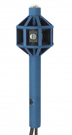
Elphel Eyesis4Pi-26-393 is the newer generation of the full-sphere multi-camera systems for stereophotogrammetric applications.
Automated panoramic imagery and 3-dimensional panoramas are the 2 main applications of Eyesise4Pi-393 camera. * Car and backpack mounts are not included. Improvements over older generation Eyesis4Pi
|
Features
- 4*π (360x180) full sphere coverage
- 64 MPix panoramic image resolution after stitching
- Final panoramic image equirectangular projection dimensions - 14000x7000
- 0.05 Pix stitching precision
- Very small parallax - distance between entrance pupils: 46.5 mm
- High resolution lenses: 26x M12 lens mount
- Calibrated fixed lens to compensate for the lenses distortions
- 10" (0.1 pix) in the center 80% x 80% area
- 30" (0.3 pix) maximal error over the full FoV
- <0.03um/° thermal expansion
- Precise image capture synchronization
- 5 FPS - maximum frame rate
- RAW or compressed image formats
- Images are geo-tagged - 5Hz GPS receiver (Locosys LS20031)
- High-precision IMU ADIS 16375
- Recording to:
- internal SSDs
- external SSDs
- a PC over network
- Web Based GUI
- SYNC cable allows:
- receive and log external trigger (from a sensor such as odometer or extra GNSS system)
- generate output signal to trigger other sensors or cameras
- Weatherproof camera body and camera pole
- The Eyesis4Pi-393 system is highly customizable
- Free Software and Open Hardware
Calibration
We have developed full calibration process and post-processing software to compensate for:
- Optical aberrations, allowing to preserve full sensor resolution over the camera FoV.
- Distortions – for precise pixel-mapping for photogrammetry and 3D reconstruction.
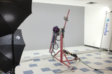
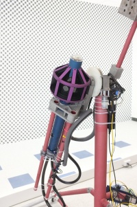
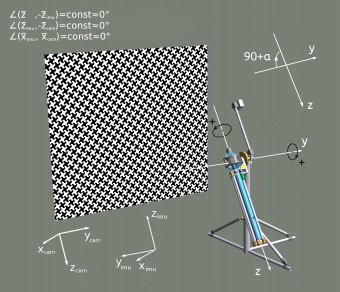
The calibration is performed using the machine (goniometer) that rotates the camera about 2 axes by precisely known angles. To calibrate IMU one needs to match the goniometer angles with the IMU data.
Check out these articles for more details:
3D Model
|
