Difference between revisions of "Eyesis4Pi"
(→Main Features) |
(→Camera Parameters) |
||
| Line 104: | Line 104: | ||
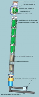
|[[File:Eyesis4pi-internals-overview.jpg | thumb | 130px | Pole Contents Schematic ]] | |[[File:Eyesis4pi-internals-overview.jpg | thumb | 130px | Pole Contents Schematic ]] | ||
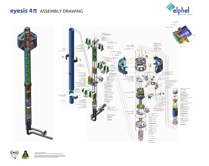
|[[File:Eyesis4pi assembly drawing scaled.jpeg|430px|thumb|Assembly Drawing, Download [http://community.elphel.com/pictures/eyesis4pi/eyesis4pi_assembly_drawing.jpeg JPEG],[http://community.elphel.com/pictures/eyesis4pi/eyesis4pi_assembly_drawing.pdf PDF]|link=http://community.elphel.com/pictures/eyesis4pi/eyesis4pi_assembly_drawing.jpeg]] | |[[File:Eyesis4pi assembly drawing scaled.jpeg|430px|thumb|Assembly Drawing, Download [http://community.elphel.com/pictures/eyesis4pi/eyesis4pi_assembly_drawing.jpeg JPEG],[http://community.elphel.com/pictures/eyesis4pi/eyesis4pi_assembly_drawing.pdf PDF]|link=http://community.elphel.com/pictures/eyesis4pi/eyesis4pi_assembly_drawing.jpeg]] | ||
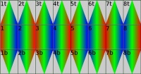
| + | |[[File:Eyesis4pi-fov.jpg | thumb | 200px | FOV of sub-cameras in Eyesis4Pi, color shows time of acquisition (from red to blue):1-8 horizontal sensors; 1t-8t top sensors;1b-8b bottom sensors]] | ||
|} | |} | ||
Revision as of 14:36, 18 October 2012
Contents
[hide]Overview
Elphel Eyesis4Pi is high resolution full sphere stereophotogrammetric camera. Camera is calibrated to compensate for optical aberrations allowing to preserve full sensor resolution over the camera FOV. Distortion calibration is performed for precise pixel-mapping to automatically stitch images into panoramas, and also for photogrammetryand 3D reconstruction.
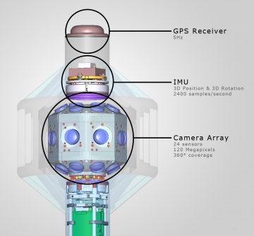
There are 24 x 5MPix sensors in the camera head, resulting in 120 MPix image acquisition. Panorama image resolution after stitching is 64 MPix. High-precision Inertial Measurement Unit IMU (ADIS 16375, 2400 samples per second) is integrated with the camera, as well as 5Hz GPS (Locosys LS20031) to provide precise position and orientation of the camera. Images, synchronized with IMU and GPS data, are recorded to internal Solid State Drives (SSD) or to an external computer over the network. Eyesis4Pi camera system includes Eyesis computer for image downloading and post-processing with pre-installed SDK and Free and Open Source Software for camera calibration, image acquisition and panorama stitching.
Eyesis4Pi can be mounted on a car for outdoor panoramic applications or carried by a person, which lets successfully create panoramas of small and narrow spaces.**
Automated panoramic imagery and 3-dimensional panoramas are 2 main applications of Eyesise4Pi camera.
Main Features
- 64 MPix panoramic image resolution after stitching
- 5 FPS - maximum frame rate
- Integrated high-precision IMU and GPS
- Recording to internal SSDs
- Web Based GUI
- Free Software and Open Hardware
Camera models
- Eyesis4Pi
24 x 5MPix sensors in the camera head plus 2 x 5MPix sensors positioned in the camera pole. This camera is better suitable for photogrammetry and 3D reconstruction.
- Eyesis4Pi-16
360*120’ panoramic camera with 16 image sensors. Does not cover nadir.
- Eyesis4Pi-24
360*180’ panoramic camera with 24 image sensors No sensors in the camera pole;
Other configurations are possible upon request.
** Car and backpack mounts are not included
Image Samples
Panorama Image Samples are available.
There are several ways to view panoramas made Eyesis4Pi:
- WebGL viewer: spherical view, which can be rotated around you as an observer. This viewer requires a browser supporting WebGL like Firefox4 or Chrome
- Equarectangular projection of spherical panorama (link to wikipedia) allows to see Jpeg image made for WebGL viewer.
- Screenshot images of panorama in WebGL viewer.
Camera Parameters
24 High Resolution Sensor Front Ends
- 5 MPix sensor (Aptina MT9P006)
- Lens (BL-04518MP125-IRCLD)
are centered and adjusted to reduce aberration. Compact Optical Layout achieves lesser parallax.
Data Storage:
- internal: 8*128 GB SSDs (Solid State Drives)
- external: over the Network
Position and Orientation Measurement:
- Inertial Measurement Unit, IMU - (ADIS 16375): 2560 recorded measurements per second
- GPS receiver (Locosys LS20031): 5-10 Hz update rate
- Odometer / Pedometer Input Interface
- Images are synchronized with IMU and GPS with 1Mu/s resolution
- GPS powered geo-tagging
Physical Characteristics:
- Weight 10 Kg
- Size 230 x 1350 mm
- Power Consumption - 50W
- Weatherproof
Image Capturing Recording Speed:
- 2.5 FPS (Frames per Second) recommended for best panorama image quality
- 5 FPS maximum recording speed
Recording Time:
- 3 hours at 2.5 FPS, to 8*128 GB SSDs internal storage.
Recording Image Format:
- JP4 (RAW format), recommended for higher quality
- JPEG
Recording Controls:
Camera Software
Camera Internal Software (Firmware):
- SDK for internal camera software customization: shared with 10353E system board SDK;
Host computer software:
All software is FOSS (Free and Open Source Software). It is experimental software that is used to test the camera performance, and it continues to be developed. All updates are available for download from git repository at SorceForge. Software may require integration with customer software depending upon camera hardware configuration and application.
Comparison between models: Eyesis4π-16, Eyesis4π-24 and Eyesis4π
| Parameter | Eyesis4Pi-16 | Eyesis4Pi-24 | Eyesis4Pi | Notes |
|---|---|---|---|---|
| Combined field of view (steradians) | 3*π | 4*π | 4*π | |
| Number of image sensors | 16 | 24 | 26 | |
| Angular resolution +/-30° from the horizon | ≥4.2Mpix/steradian | ≥4.2Mpix/steradian | ≥4.2Mpix/steradian | 1 |
| Angular resolution +30° to +90°(zenith) | ≥4.2Mpix/steradian | ≥4.2Mpix/steradian | ≥4.2Mpix/steradian | 1 |
| Angular resolution -30° to -90°(nadir) | none | ≥4.2Mpix/steradian | ≥4.2Mpix/steradian | 1 |
| Combined megapixels | 80.0 | 120.0 | 130.0 | |
| Combined megapixels (w/o overlapping areas) |
48.0 | 64.0 | 64.0 | 2 |
| Combined megapixels (w/o overlapping areas, worst case resolution) |
39.6 | 52.8 | 52.8 | 1, 2 |
| Additional sensors for camera egomotion measurement |
No | No | Yes | 3 |
| Distance between entrance pupils of adjacent horizontal lenses |
46.5mm | 46.5mm | 46.5mm | |
| Distance between entrance pupils of horizontal and top/bottom lenses |
50mm | 50mm | 50mm | 3 |
| Maximal frame rate | 5fps | 5fps | 5fps | 4 |
| Maximal recording data rate | 128MB/s | 128MB/s | 144MB/s | |
| Maximal direct network data rate | 60MB/s | 80MB/s | 90MB/s | |
| GPS receiver | Locosys LS20031 | Locosys LS20031 | Locosys LS20031 | |
| GPS pulse-per-second input | yes | yes | yes | |
| IMU | ADIS163xx | ADIS163xx | ADIS163xx | |
| Data unload | eSATAx2 | eSATAx2 | eSATAx2 | |
| Storage devices type | 1.8"SSD | 1.8″SSD | 1.8″SSD | |
| Number of storage devices | 8 | 8 | 9 |
Notes:
- Angular resolution per pixel differs in the sub-camera FOV, minimal resolution is used.
- Megapixels of 2 additional lenses are not included in total panoramic image size.
- Additional pair of sub-cameras mounted one meter below the main 24 sensors. These camera images may be used to measure distances to some objects (not the full sphere), and then this data can be used to improve precision of the IMU-based measurements of the camera egomotion.
- Frame rate may be limited by the recording (or network if the SSD are not used) datarate for high compression quality (>0.3 bytes/pixel), required for the aberration correction.
Camera Operation Workflow
Step by step workflow starting from setting the camera controls during recording and footage acquisition to post-processing of the recorded data and final panorama output.
Eyesis4Pi System Sales Kit
- Eyesis4Pi camera
- Computer* with Post-processing tools and SDK
Small form factor Shuttle PC; Intel Core i7-950 Quad-Core Processor; 16 GB DDR3 RAM; GeForce GTX 465 (Fermi) 1GB; 2 TB HDD;
- Ethernet switch ( )
- Shipping and storying case*: 52”x15”x18” ( heavy-duty plastic case for safe shipping) ( photo)
* Configuration is subject to change
List Prices
- Eyesis4Pi 95,000 USD
- Eyesis4Pi-24 75,000 USD
- Eyesis4Pi-16 60,000 USD
GPL and Volume discounts are available.
How to buy
We are directly accepting orders and ship worldwide. Please contact Elphel for Lead Time and Quotes:
- Email (Sales Inquiry): sales@elphel.com
- Phone: (801) 783-5555 x 107
- Toll-free: (888) 3 ELPHEL
- Fax: (801) 812-8267
FAQs
- What software do I need on my laptop/computer to control Eyesis?
Eyesis GUI requires a locally running webserver (apache2 + PHP5) and the Eyesis4Pi User Guide software.
- How do I connect my laptop/computer to Eyesis and how do I control image recording?
The Eyesis4Pi hosts a Gigabit Ethernet switch so all you need is one Ethernet cable from the camera pole hose to your laptop/computer.
The Eyesis GUI is completely browser based so after you connected to the network you just start a browser type in the correct URL and you are ready to go.
- How do I unload the data from Eyesis4Pi?
The camera pole has 2 eSATA ports in a weatherproof sealed connector. With this connector you can connect to the SSDs inside the camera pole like to any external hard-drive with any laptop/computer.
- Why are there 9 SSDs and not just a single bigger one?
There are 26 sensor-front-ends. There are 9 system boards each connected to 3 sensor-front-ends and a one SSD. The shots of a single panorama are split up on 9 SSDs. 3 images to SSD1, 3 images to SSD2, 3 images to SSD3... and the last 2 - to SSD9
- Can I also use Eyesis4Pi with HDDs instead of SSDs?
We initially tested the system with HDDs but due to strong vibrations when using Eyesis mounted to a car roof we experience massive write-rate drops with HDDs. After we switched to SSDs all these problems were gone. If your Eyesis application does not involve bumby roads or vibrations HDDs should work just fine though.
- Does the camera need regular calibration?
The camera needs to be calibrated once when we assemble it and each camera has it's unique set of calibration files, needed for post-processing of the images.
- Is the camera easy to work with or do we need some special training?
We would recommend some training (either visit us at Elphel for 2-3 days, or have our engineer visit your company). Although we offer technical support on public mailing list and we can help you to get started as well as answer questions about camera operation and post-processing.
- The product named as stereophotogrammetric camera however we couldn't find any information about stereo feature. We appreciate if you can give us further information about availability of this
feature.
"stereophotogrammetric" means that camera uses multiple images acquired from different locations in 3d space to measure object geometrical properties. In a single shot (image set) the camera provides accurate angular measurement of the acquired images, or to be precise - maps pixels in the images to particular lines in space in the camera coordinate system, because each of the camera lenses has different coordinates and just angular coordinates are not sufficient for mapping. The angular precision of the measurements is better than 1 angular minute in each direction.
Most useful way to do a 3d reconstruction is to use at least 2 image sets (each covering full sphere) acquired from different locations, but that requires precise knowledge of the camera positions and orientations in these points (camera egomotion). Eyesis camera hardware is designed to acquire the following data to provide this information: - high resolution ("near tactical grade" ADIS16375- "tactical grade" ADIS16485 also available) inertial measurement unit that acquires and logs data at 2.5 thousand samples per second. - Additional pair of sub-cameras mounted one meter below the main 24 sensors. These camera images may be used to measure distances to some objects (not the full sphere), and then this data can be used to improve precision of the IMU-based measurements of the camera egomotion.
- With the open source software provided is it possible to do measurement from the images gathered by the camera?
All the software we develop/use is immediately available online. The code itself is hosted at Sourceforge.net, documentation - on our wiki. The software that we currently developed is intended to provide accurate mapping of the pixels to the lines in space. Among others it includes lens distortion calibration and correction and measurement of each camera sub-module location and orientation. This software DOES NOT yet include any measurements of the acquired objects - currently this has to be done with one of the existent software packages.
More Information
Wiki:
- Workflow
- User Guide - Recording
- User Guide - Post-Processing: Footage Procedures
- User Guide - Post-processing: ImageJ
- Data Structure Description
- Calibration Process
Elphel Development Blog:
- Current state of the Eyesis project Introdcution of Eyesis4Pi
- “Zoom in. Now… enhance.” – a practical implementation of the aberration measurement and correction in a digital camera
- “Zoom in. Now… enhance.” – Results
- Elphel Eyesis camera optics and lens focus adjustment
- Elphel-Eyesis, assembled
- Elphel-Eyesis Progress
- First Elphel Eyesis Prototype assembled


